Alternate Text

Roman Roads

The long straight roads built by the Romans wherever they conquered have, in many cases, become just as famous names in history as their greatest emperors and generals. Building upon more ancient routes and creating a huge number of new ones, Roman engineers were audacious in their plans to join one point to another in as straight a line as possible whatever the difficulties in geography and the costs in manpower. Consequently, roads used bridges, tunnels, viaducts, and many other architectural and engineering tricks to create a series of breathtaking but highly practical monuments which spread from Portugal to Constantinople. The network of public Roman roads covered over 120,000 km, and it greatly assisted the free movement of armies, people, and goods across theempire. Roads were also a very visible indicator of the power of Rome, and they indirectly helped unify what was a vast melting pot of cultures, races, and institutions.

THE ROMAN ROAD NETWORK

The Romans did not invent roads, of course, but, as in so many other fields, they took an idea which went back as far as the Bronze Age and extended that concept, daring to squeeze from it the fullest possible potential. The first and most famous great Roman road was the Via Appia (or Appian Way). Constructed from 312 BCE and covering 196 km (132 Roman miles), it linked Rome to Capua in as straight a line as possible and was known to the Romans as the Regina viarum or 'Queen of Roads'. Much like a modern highway, it did not go through less important towns along the way, and it largely ignored geographical obstacles. For example, the impressive 90 km stretch from Rome to Terracina was built in a single straight line. The road would later be extended all the way to Brundisium and thus reach 569 km in length (385 Roman miles).

Other famous roads in Italy were the Via Flaminia which went from Rome to Fanum (Fano), the Via Aemilia from Placentia to Augusta Praetoria (Aosta), the Via Postumia from Aquileia to Genua (Genoa), the Via Popillia from Ariminum (Rimini) to Padova in the north and from Capua to Rheghium (Reggio Calabria) in the south, and many more besides, all with extensions made over time. The roads became so famous that they even gave their names to places and regions. The network gradually spread across the empire from Britain to Syria, and certain roads became as well-known and well-travelled as those around Rome itself. For example, the Via Domitia (begun in 116 BCE) went from the French Alps to the Pyrenees and was invaluable for troop movements in the campaigns in Spain. There was also the Via Egnatia (begun in the mid-second century BCE), which crossed the Balkan Peninsula and ended at Byzantium, making it a vital land route between the western and eastern parts of the empire.

To achieve the objective of constructing the shortest routes possible between two points (often not visible one to the other), all manner of engineering difficulties had to be overcome. Once extensive surveying was carried out to ensure the proposed route was actually straight and determine what various engineering methods were required, marshes had to be drained, forests cut through, creeks diverted, bedrock channelled, mountainsides cut into, rivers crossed with bridges, valleys traversed with viaducts, and tunnels built through mountains. Once all that was done, roads had to be levelled, reinforced with support walls or terracing and then, of course, maintained, which they were for over 800 years.  

Besides permitting the rapid deployment of troops and, more importantly, the wheeled vehicles which supplied them with food and equipment, Roman roads allowed for an increase in trade and cultural exchange. Roads were also one of the ways Rome could demonstrate its authority. For this reason many roads began and ended in atriumphal arch, and the imperial prestige associated with realising the project was demonstrated in the fact that roads were very often named after the magistrate official who funded it; hence, for example, the Via Appia takes its name from the censor Appius Claudius Caecus.

ROAD DESIGN & MATERIALS

Major roads were around a standard 4.2 m wide, which was enough space for two wheeled-vehicles to pass each other. Roads were finished with a gravel surface sometimes mixed with lime or, for more prestigious sections such as near towns, with dressed stone blocks of volcanic tuff, cobbles, or paving stones of basalt (silice) or limestone. First a trench was dug and a foundation (rudus) was laid using rough gravel, crushed brick, clay materials or even wooden piles in marshy areas, and set between curb stones. On top of this a layer of finer gravel was added (nucleus) and the road was then surfaced with blocks or slabs (summum dorsum). Mountain roads might also have ridges running across the surface to give people and animals better traction and have ruts cut into the stone to guide wheeled vehicles.

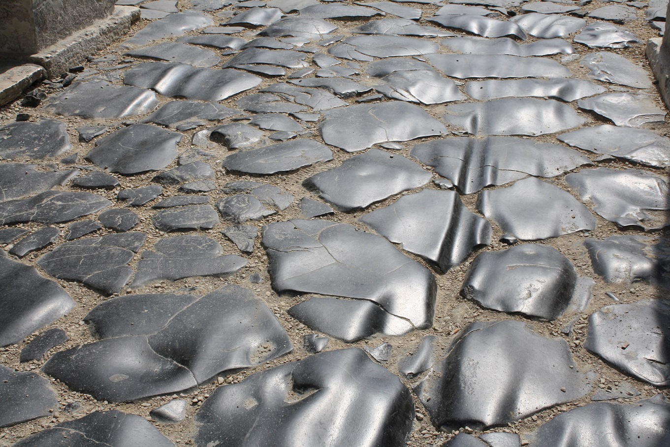
Roads were purposely inclined slightly from the centre down to the curb to allow rainwater to run off along the sides, and for the same purpose many also had drains and drainage canals. A path of packed gravel for pedestrians typically ran along each side of the road, varying in width from 1-3 metres. Separating the path from the road, the curb was made of regular upright slabs. In addition, every 3-5 metres there was a higher block set into the curb which stopped wheeled traffic riding onto the footpath and allowed people to mount their horses or pack animals. Busier stretches of main roads had areas where traffic could pull over and some of these had services for travellers and their animals too. Milestones were also set up at regular intervals and these often recorded who was responsible for the upkeep of that stretch of the road and what repairs had been made.

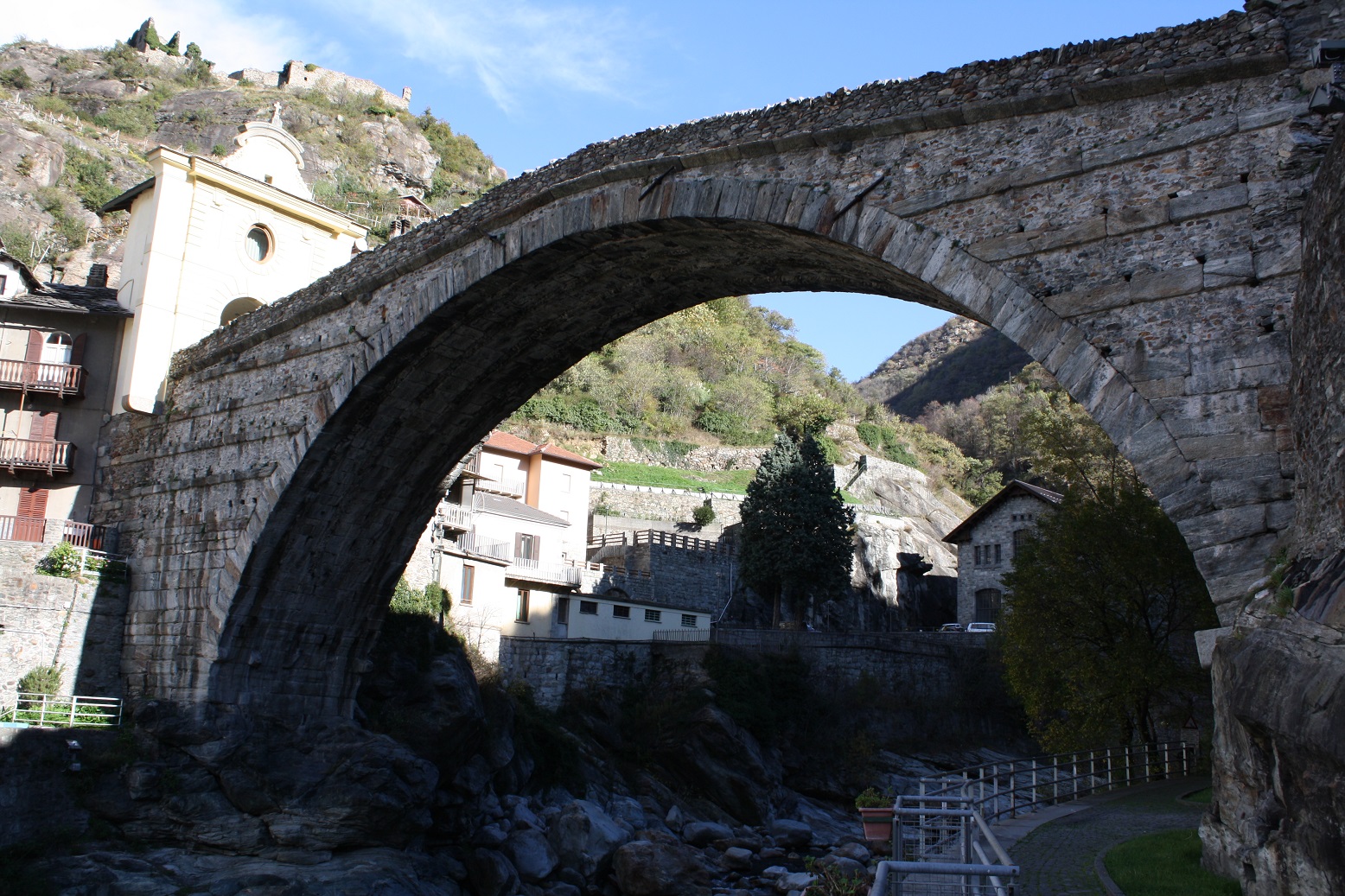
BRIDGES, VIADUCTS, & TUNNELS

Lasting symbols of the imagination of Roman engineers are the many arched bridges and viaducts still standing around the empire. From early bridges such as the Ponte di Mele near Velletri with its single vault and modest span of 3.6 m to the 700 m long, 10-arch viaduct over the Carapelle River, these structures helped achieve the engineers' straight-line goal. The Romans built to last, and the piers of bridges which crossed rivers, for example, were often built with a more resistant prow-shape and used massive durable blocks of stone, while the upper parts were either built of stone blocks strengthened with iron clamps, used cheaper concrete and brick, or supported a flat wooden superstructure. Perhaps the most impressive bridge was at Narni. 180 m long, 8 m wide and as high as 33 m, it had four massive semicircular arches, one of which, stretching 32.1 m, ranks as one of the longest block-arch spans in the ancient world. Two of the best surviving bridges are the Milvian bridge in Rome (109 BCE) and the bridge over the river Tagus at Alcantara (106 BCE) on the Spanish-Portuguese border.

Tunnels were another essential feature of the road network if lengthy detours were to be avoided. The most important include three tunnels built in the 1st century BCE: Cumaea, which stretched 1,000 m in length, Cripta Neapolitano measuring 705 m, and Grotta di Seiano 780 m long. Tunnels were often built by excavating from both ends (counter-excavation), a feat which obviously required precise geometry. To make sure both ends met, shafts were sometimes drilled down from above to check the progress of the work, and shafts could also be used to speed up excavation and work at the rock from two angles. Nevertheless, when working through solid rock, progress was tediously slow, perhaps as little as 30 cm a day, resulting in tunnel projects lasting years.

CONCLUSION

Roman roads were, then, the arteries of the empire. They connected communities, cities, and provinces, and without them the Romans could surely not have conquered and held onto the vast territories they did over so many centuries. Further, such was the engineering and surveying skills of the Romans that many of their roads have provided the basis for hundreds of today's routes across Europe and the Middle East. Many roads in Italy still use the original Roman name for certain stretches, and even some bridges, such as at Tre Ponti in modern Fàiti, still carry road traffic today.

read more...
Alternate Text

Teotihuacan

Teotihuacan, located in the Basin of Central Mexico, was the largest, most influential, and certainly most revered city in the history of the New World, and it flourished in Mesoamerica's Golden Age, the Classic Period of the first millennium CE. Dominated by two gigantic pyramids and a huge sacred avenue, the city, its architecture, art, and religion would influence all subsequent Mesoamerican cultures, and it remains today the most visited ancient site in Mexico.

HISTORICAL OVERVIEW

In relation to other Mesoamerican cultures Teotihuacan was contemporary with the early Classic Maya (250 - 900 CE) but earlier than the Toltec civilization (900-1150 CE). Located in the valley of the same name, the city first formed between 150 BCE and 200 CE and benefitted from a plentiful supply of spring water which was channelled through irrigation. The largest structures at the site were completed before the 3rd century CE, and the city reached its peak in the 4th century CE with a population as high as 200,000. Teotihuacan is actually the Aztecname for the city, meaning "Place of the Gods"; unfortunately, the original name is yet to be deciphered from surviving name glyphs at the site.

The city's prosperity was in part based on the control of the valuable obsidian deposits at nearby Pachuca, which were used to manufacture vast quantities of spear and dart heads and which were also a basis of trade. Other goods flowing in and out of the city would have included cotton, salt, cacao to make chocolate, exotic feathers, and shells. Irrigation and the natural attributes of local soil and climate resulted in the cultivation of crops such as corn, beans, squash, tomato, amaranth, avocado, prickly pear cactus, and chili peppers. These crops were typically cultivated via the chinampa system of raised, flooded fields which would later be used so effectively by the Aztecs. Turkey and dogs were husbanded for food, and wild game included deer, rabbits, and peccaries, whilst wild plants, insects, frogs, and fish also supplemented a diverse diet. In addition, the city displays evidence of textile manufacturing and crafts production. Teotihuacan also had its own writing system which was similar to, but more rudimentary than, the Maya system and generally limited in use to dates and names, at least in terms of surviving examples.

At its peak between 375 and 500 CE, the city controlled a large area of the central highlands of Mexico and probably exacted tribute from conquered territories via the threat of military attack. Teotihuacan's fearsome warriors, as depicted on murals, carry atlatl dart-throwers and rectangular shields, and they wear impressive costumes of feather headdresses, shell goggles, and mirrors on their backs. Evidence of cultural contact in the form of Teotihuacan pottery and luxury goods is found in elite burials across Mexico and even as far south as the contemporary Maya centres of Tikal and Copan.

Mysteriously, around 600 CE, the major buildings of Teotihuacan were deliberately destroyed by fire, and artworks and religious sculptures were smashed in what must have been a complete changing of the ruling elite. The destroyers may have been from the rising city of Xochicalco or from within in an uprising motivated by a scarcity in resources, perhaps acerbated by extensive deforestation (wood was desperately needed to burn huge quantities of lime for use in plaster and stucco), soil erosion, and drought. Whatever the reason, after this climatic event, the wider city remained populated for another two centuries but its regional dominance became only a memory. 


TEOTIHUACAN RELIGION

The most important deity at Teotihuacan seems to have been, unusually for Mesoamerica, a female. The Spider Goddess was a creator deity and is represented in murals and sculpture and typically wears a fanged mask similar to a spider's mouth. Other gods, who would become familiar in subsequent Mesoamerican civilizations, included the Water Goddess, Chalchiuhtlicue, who is impressively represented in a three-metre high stone statue, and the rain and war god Tlaloc. Clearly, there was a preoccupation with life-giving water in such an arid climate. Other deities often represented in Teotihuacan art and architecture include the feathered-serpent god known to the Aztecs as QuetzalcoatlXipe Totec, who represented agricultural renewal (especially maize), and the creator god known as the Old Fire God. The positioning of temples and pyramids in alignment with the sun on the June solstice and the Pleiades suggests calendar dates were important in rituals, and the presence of buried offerings and sacrificial victims illustrates the belief in the necessity to appease various gods, especially those associated with climate and fertility.

ARCHITECTURAL LAYOUT & FEATURES

The city, covering over 20 square kilometres, has a precise grid layout oriented 15.5 degrees east of true north. The city is dominated by the wide Avenue of the Dead (or Miccaotli as the Aztecs called it) which is 40 metres wide and 3.2 km long. The avenue begins in agricultural fields and passes the Great Compound or market place, Citadel, the Pyramid of the Sun, many other lesser temples and ceremonial precincts, and, culminating at the Pyramid of the Moon, points towards the sacred mountain Cerro Gordo. Archaeology has discovered that the original avenue was much longer than is visible today and is dissected by another avenue which thus created a city of four quarters. The site is dominated by the two great pyramids of the sun and moon and the Temple of Quetzalcoatl, but most buildings were more modest and take the form of small groups of buildings (over 2,000 of them) organised around a courtyard and the whole surrounded by a wall. It was here in the compound that daily cooking was done using clay braziers. Many compounds have one or two burial spaces suggesting that each was a family or kin group, and some cover several thousand square metres and so may be better described as palaces. Other compounds are more modest and use less fine building materials so that they may have been workshops for artisans. Many compounds also have large cisterns offering the possibility of independent water supply. The city had ethnic zones: Zapotecs in the western area and Maya in the eastern, for example. Typical features of the site's architecture include single-storey structures, flat roofs with occasional open portions, and decorative vertical rectangular panels set on a sloping support wall (talud-tablero) which were inset into the sloping facades of all types of religious buildings and which were much copied across Mesoamerica.

read more...
Alternate Text

The Aztec New Fire Ceremony

The New Fire Ceremony, also known as the Binding of the Years Ceremony, was a ritual held every 52 years in the month of November on the completion of a full cycle of the Aztec solar year (xiuhmopilli). The purpose of it was none other than to renew the sun and ensure another 52-year cycle. The New Fire Ceremony, or Toxhiuhmolpilia, as the Aztecs themselves called it, was by far the most important event in the religious calendar because, quite simply, if the ceremony failed, then the Aztec civilization would end.


THE SOLAR CALENDAR

The timing of the ceremony and the number 52 were significant as this was the exact coinciding point of the first days of the two Aztec calendars which were then in simultaneous use: the ancient Mesoamerican and sacredtonalpohualli 260-day cycle and the xiuhpohualli, the Aztec 365-day solar and ceremonial calendar. In addition, every second cycle (104 years) was given even more significance as on that precise date the tonalpohuallicoincided with the 52-year cycle. The Aztecs saw such time cycles as a mirror of the ancient cosmic cycles which, in Aztec mythology, had created the world. The historian Jacques Soustelle describes well the reason a ritual like the New Fire Ceremony was of such concern to the Aztecs,

XIUHTECUHTLI GOD OF FIRE

The ceremony was overseen by Xiuhtecuhtli, also known as the 'Turquoise Lord', the Aztec god of fire. His name reveals not only his association with turquoise but also with Time, as xiuhitl in Nahuatl, the language of the Aztecs, meant both 'turquoise' and 'year'. Fire, as with many other ancient cultures, was considered a fundamental element of the universe, present in all things. Xiuhtecuhtli's pillar of fire was believed to run right through the cosmos from Mictlan, the Underworld, to Topan, the Heavens. The association between the sun and fire is made in Aztec mythology with the self-sacrifice of the gods Nanahuatzin and Tecuciztecatl who threw themselves into a fire atTeotihuacan in order to produce the Sun and Moon respectively. As we shall see, in the New Fire Ceremony one particular fire was essential to the success of ensuring the return of the life-giving sun.

PREPARATION FOR THE CEREMONY

Preparation for the ceremony began with the extinguishing of all fires of any kind, from temples to household hearths - the latter being especially associated with Xiuhtecuhtli. Next, a thorough cleaning operation was undertaken with the streets being swept, old hearth stones were thrown away along with old cooking utensils, old clothes too, and even idols were ceremoniously washed and cleansed. Another ritual was to tie bundles of 52 reeds together, creating a symbolic xiuhmopilli. Pregnant women were locked in granaries and their faces were painted blue in the belief that they would not then turn into monsters during the night. Children also had their faces painted and were kept from sleeping to prevent them turning into mice. Finally, as darkness fell, the populace stopped all activities, climbed the roofs of their homes and waited with a hushed silence and baited breath for what was to come. 

THE NEW FIRE CEREMONY IN ART

The New Fire Ceremony is referred to in various instances of Aztec and colonial art. Stone sculptures representing the xiuhmopilli bundles have been excavated at Tenochtitlan, each with a date stamp hieroglyph of the year they were produced. The ceremony of relighting the fires at Tenochtitlan is represented in an illustration in the Codex Borbonicus (Sheet 34), c. 1525 CE. Priests carry bundles to transfer the fire and they wear turquoise masks, as do other citizens, including women and children. Also included is an image of Montezuma (aka Motecuhzoma II), the Aztec ruler who presided over that final ceremony in 1507 CE.

One of the most famous of all Aztec artworks is the turquoise mosaic mask of Xiuhtecuhtli now in the British Museum. Perhaps similar to the masks worn by the High Priests in the Fire ceremony it has conch shell eyes and dates to the 14th century CE. Finally, the celebrated Throne of Motecuhzoma II was specifically sculpted to commemorate the New Fire Ceremony of 1507 CE. The throne has date glyphs carved on the front, a depiction of Xiuhtecuhtli and other gods at the sides, and the seat back carries a large sun disk.

read more...